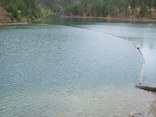
Garnet Valley Dam
The first section passes many small farms and ranches. I did notice a wild peach tree, but even in mid-September the fruit was still small and hard. Perhaps some years they might size up or ripen but it does not look good for this year. The rock out-crops on the steep sides of this narrow valley clearly show the fragile nature of the soils on these hills. Near where the dirt road begins, the narrow valley becomes more of a canyon and the road twists and turns through the bottom. There is little sign of the creek that comes from the dam.
Reaching the dam I was disappointed that the area where we used to launch the boats and park was now fenced off. There were some access points through the fence, but a large man or a person with a canoe or boat would have a tough to access the lake. I carried on up a little hill and found a parking spot with a locked gate through which I could see a couple of picnic tables and some toilet facilities.
Here there was a better walkway through the fence, but it would still be rather awkward carrying a canoe through the narrow angled passage. There was a sign prohibiting swimming, campfires, barbeques, boat motors and ice fishing. It is sad that more reservoirs are becoming more restricted to public use. (If we all treat these areas with respect we will retain the privilege of using them in the future. Tread lightly and leave as faint a footprint as possible.) This area is bench land with lots of Jack Pine and is relatively flat, but the bank down to the lake is fairly steep for most part. the easiest place to launch a canoe would be to head back towards the dam as the slope here is gentler.
The southern section of the lake is steep on both the eastern and western shores. The western side is more rugged with some areas of broken rock slope. Towards the north there is a little better foreshore, but at the moment I’m not sure of public access via these roads.
I could not find a record of any recent stockings, but we used to catch brook trout here years ago. On my first cast this day I had two strikes, but that was all for the next half hour. Alas, all too soon I had to pack up my rod and leave for other duties. I would have liked to explore the shoreline towards the northern end where there are more shallows for the fish to feed. Perhaps next year I will find more time in the warmer weather.
Now with October upon us it's not quite time to put away the canoe and fly rods, but time to take out the guns and spinning outfit and explore more of the high country looking for those small out-of-the-way lakes while looking to fill the freezer with venison.
Now that all the wild walnuts are hulled, it’s time to re-sort the tackle box in the evenings and to make my backpack anchor bags, time to study the maps looking for those little out-of-the-way spots that need a little more fishing pressure. Yes, after 60-plus years there is still plenty to discover in these glorious hills.

Great post. Brought back memories from years ago (I must have been about 12 years old, lol) going fishing up there in a little rowboat. Don't remember much about the fishing but will never forget all the dragonflies!
ReplyDeleteTried to email you with a writing opportunity you might be interested in ... but got message the addy I have for you is no longer in service??
Moving there in may...bought 57.5acres beautiful home with access to that gorgeous lake can't wait to enjoy it
ReplyDelete